Embed Size (px)
Citation preview
Record of Metal Workshops in PeatDeposits: History andEnvironmental Impact on the MontLozere Massif, FranceS . B A R O N , * , † M . L A V O I E , ‡ , § A . P L O Q U I N , †
J . C A R I G N A N , † M . P U L I D O , ‡ A N DJ . - L . D E B E A U L I E U ‡
Centre de Recherches Petrographiques et Geochimiques, CNRSNancy, 15 rue Notre Dame des Pauvres, BP 20, 54 501Vandoeuvre les Nancy, France, and Institut Mediterraneend’EÄ cologie et de Paleoecologie, Case 451, Faculte Saint-Jerome,Universite d’Aix-Marseille III, Marseille Cedex 20, France
This study aims to document the history of the metallurgicalactivities on the Mont Lozere massif in the CevennesMountains in Southern France. Many medieval sites ofmetallurgical wastes (slags) have been reported on themassif. These sites are thought to represent ancient leadworkshops. The impact of past metallurgical activity onthe environment was studied using geochemical andpalynological techniques on a core collected in the NarsesMortes peatland near medieval smelting area. Two mainperiods of smelting activities during the last 2200 years wererevealed by the lead concentration and isotopic compositionalong the core profile: the first period corresponds tothe Gallic period (∼ca. 300 B.C. to ca. 20 A.D.) and the secondone to the Medieval period (∼ca. 1000-1300 A.D.).Forest disturbances are associated with lead anomaliesfor the two metallurgical activities described. The impactof the first metallurgy was moderate during the Gallic period,during which beech and birch were the tree speciesmost affected. The second period corresponds to theobserved slag present in the field. Along with agropastoralactivities, the medieval smelting activities led to thedefinitive disappearance of all tree species on the summitzones of Mont Lozere. The abundance of ore resourcesand the earlier presence of wood on the massif justify thepresence of workshops at this place. The relationshipbetween mines and ores has been documented for theMedieval period. There is no archaeological proof concerningthe Gallic activity. Nevertheless, 2500-2100 years ago,the borders of the Gallic Tribe territory, named the Gabales,were the same as the present-day borders of the Lozeredepartment. Julius Caesar reported the existence of this tribein 58 B.C. in “De Bello Gallico”, and in Strabon (Book IV,2.2) the “Gabales silver” and a “treasure of Gabales” arementioned, but to this day, they have not been found.
IntroductionAtmospheric deposition resulting from anthropogenic activityare recorded in natural archives such as ice cores (1, 2),
peatlands (3-5), marine sediments (6), lake sediments (7, 8),and lichens (9-11). These archives record atmosphericpollution at regional or continental scale. Records at globalscale have been reported (12, 13), but very few studies havebeen conducted at regional scale (14, 15). The knowledge oflocal history allows more accurate estimation of the sourcesof the heavy metals accumulated in the environment. Insouthern France, 60 metallurgical waste (slag) sites have beenfound on the Mont Lozere massif suggesting that metal-lurgical activities occurred in the past (16, 17).
Fens are the most common peatlands in southern Europe.This type of peatland is not frequently used to reconstructchanges in past atmospheric deposition because of possibledisturbances of the geochemical signal resulting from leach-ing and groundwaters (18). Although bogs are recognized tobe a better geochemical archive, it has recently been shownthat fens are also able to record successfully atmosphericdeposition without significant distortion (19). This wasdeduced from the study of ombrotrophic peatlands wherethe underlying peat was minerotrophic (20, 21). Moreover,West et al. (20) demonstrated that high ash content in peatis not necessarily associated with high lead concentration,suggesting that variations in lead concentrations might notbe the result of changes in the mineral fraction sedimentation.As a result, minerotrophic peatlands give the opportunity toestablish local and regional environmental reconstructionsin areas where bogs are absent.
This study presents geochemical and pollen analyses ofa core collected in a minerotrophic peatland on the MontLozere massif. Our aim is to document periods of localmetallurgical activities during the last millennia and toexamine their impact on the long-term forest dynamics.Elemental chemical analyses, lead isotopic compositions,and pollen analyses were used to reconstruct the history ofthe anthropogenic activities. The lead isotopic signature alongthe peat core allowed tracing the natural and anthropogenicorigins of lead and constraining the role of human activitiesrelated to vegetation disturbance observed in the pollenrecords.
Materials and MethodsStudied Area and Site. Mont Lozere is located in the CevennesNational Park (French Massif Central) and is a part of animportant mining district. It is a 300 million year old graniticmassif, surrounded by various Pb mineralizations.
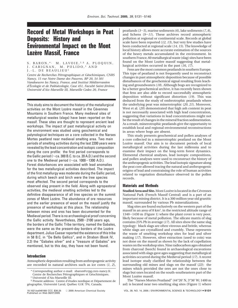
Slag sites are found exclusively on the western part of themassif in an area of 8 km2, in the restricted altitude range of1340-1430 m (Figure 1) where the plant cover is very poor,likely because of metal pollution. The silicate matrix of slagcontains 25% Pb in average (17). All sites show the same slagtypology: black slags are often vitreous and brittle, whereaswhite slags are crystallized and crumbly. These representsthe waste of smelting workshop sites for lead and silvermaking (17). However, silver extraction (used to coin) wasnot done on the massif as shown by the lack of cupellationwastes on the workshop sites. Nine radiocarbon ages obtainedfrom charcoal (beech) found in archaeological excavationsassociated with slags gave ages suggesting that metallurgicalactivities occurred during the Medieval period (17). A recentlead isotope study clarified the relationship between thesurrounding old mines and slags on the massif (22): themines which provided the ores are not the ones close toslags but ones located on the south-southeastern part of theMont Lozere massif.
The “Narses Mortes Peatland” (44°26′ N, 3°36′ W; 1400 masl) is located near two smelting slag sites (Figure 1) where
* Corresponding author e-mail: [email protected].† Centre de Recherches Petrographiques et Geochimiques.‡ Universite d’Aix-Marseille III.§ Present address: Centre d’etudes nordique et Departement de
geographie, Universite Laval, Quebec G1K 7P4, Canada.
Environ. Sci. Technol. 2005, 39, 5131-5140
10.1021/es048165l CCC: $30.25 2005 American Chemical Society VOL. 39, NO. 14, 2005 / ENVIRONMENTAL SCIENCE & TECHNOLOGY 9 5131Published on Web 06/07/2005
an archaeological excavation was engaged (17, 23). It is a 21ha treeless fen dominated by Sphagnum mosses and Moliniacaerula (L.) Moench. A microtopographic pattern of hollowsand hummocks characterizes the site. The organic sedimentthickness reaches a maximum of 140 cm, and a radiocarbondate of 8150 14C yr B.P. was obtained for the onset of peatinception at the center of the peatland (24). The surroundingvegetation consists of a heatland dominated by Callunavulgaris (L.) Hull, in association with Vaccinium myrtillus L.,Cytisus scorparius (L.) Link, and Nardus stricta L. Scots pine(Pinus sylvestris L.) is the only tree species and was plantedduring the second half of the XIXth century.
Sampling. According to palynological studies conductedat the studied site (24, 25), the marginal peat is moreappropriate than the central part of the peatland to study indetail the anthropogenic period. In May 2002, a 140 cm-longpeat profile was extracted at the western margin of thepeatland i.e. out of the way of water draining the workshop3-3′. The upper part of the profile consists of a 15 × 15 × 75cm monolith, whereas the deeper sediments (76-140 cm)consist of a core collected using a modified Russian peatsampler. Sediments were wrapped in a plastic film andtransported to the laboratory, where they were stored at 5°C. Granite samples were also collected for an estimation ofthe local crustal composition.
Peat Sample Treatment. The superficial part of thesediments as well as roots and living plant materials werediscarded in order to remove potential contamination. Theprofile was divided into two longitudinal parts: one for thegeochemical analysis and the other one for the palynologicalanalysis and radiocarbon dating. The profile was sectionedinto 2-cm thick slices. The upper part of the core (21-0 cmdepth) has not been sampled for geochemistry because ofthe abundant roots and living plants. These last sampleswould have been inconsistent with routine analytical protocol
applied here. Samples for geochemistry were dried at 30 °Cduring 5 days in a polypropylene box for conservation untilthe chemical analysis. Each sample was powdered in an agatemortar. After powdering, samples were sifted in an inorganicsieve (500 µm mesh) in order to obtain a homogeneouspowder without roots or large components of flora.
Ash Content. Ash content was determined by gravity using1 g of sediment previously dried at 105 °C. Ashing was doneby heating at 550 °C overnight in order to obtain a whitecolor as indication that all the organic matter was burned.
Elemental Chemical Analysis of Peat Samples. Elementalchemical composition was measured using a ThermoElemental ICP-MS X7. Suprapure reagents were used for thepreparation of samples, such as distilled-deionized water,distilled acids, and a homemade synthesized Li metaborateflux. All samples were digested using alkali fusion. Aftercooling, the fusion glass was dissolved with nitric acid andintroduced in the mass spectrometer (26). Procedural blankswere carried out and were negligible (26). For the sampleshaving predominant organic matter content, the accuracyand the reproducibility were verified by using the BCR-CRM482 lichens reference material and are as reported by Doucetand Carignan (10). The accuracy and the reproducibility ofhigh ash content samples were verified by using geologicalreference materials and are as reported by Carignan et al.(26).
Lead Isotopic Measurements. Dried peat samples (30-300 mg, according to lead concentration in each sample)were dissolved in a Teflon vessel using 2 mL of concentratedHNO3 and 0.5 mL of 30% H2O2. The Teflon vessels were sealedand left at room-temperature overnight. After evaporationat 110 °C, the residue was taken back with 1 mL ofconcentrated HNO3, 0.5 mL of H2O2, and 1 mL of concentratedHF (all Merck Suprapur quality) and set at 80 °C overnight.
FIGURE 1. Location of the Mont Lozere massif (Cevennes mountains) in southern France. The locations of the Narses Mortes Peatlandand the granites samples are also indicated.
5132 9 ENVIRONMENTAL SCIENCE & TECHNOLOGY / VOL. 39, NO. 14, 2005
H2O2 was added to the Teflon vessel step by step in order toovoid effervescence of the organic matter. Samples weredigested in a clean room laboratory under a laminar flowhood to avoid any contamination. After the last evaporation,the residue was taken up in 1 mL of 0.9 M HBr and stayedat the room-temperature overnight in order to homogenizethe solution with the residue. The samples were thenultrasonized for 1 h. After centrifugation, Pb was separatedfrom the other elements by ion exchange using the AG1X8resin (27). After separation, the solution was evaporated at80 °C, and the residue was taken back in 3 mL of 0.3 M HNO3.
The lead isotopic composition was measured with aMC-ICP-MS (Isoprobe, Micromass, now GV Instruments)equipped with 9 Faraday cups allowing the measurement ofall the Pb isotopes, Tl isotopes, and 200Hg simultaneously.The reference materials, NIST 981 Pb and NIST 997 Tl, wereused to correct for instrumental mass bias, according to theempirical technique used by Marechal et al. (28) and reportedby White et al. (29) for lead applications. This technique isbased on the relationship measured between Pb and Tl massbias. Reference values used for both reference materials weretaken from Thirlwall (30). A Pb/Tl ratio of 10 was used forboth the reference solution and samples. Repeated mea-surements of the NIST NBS 981 Pb reference material yieldedaccurate recalculated values (using the Pb-Tl relationship)with a reproducibility (2*standard deviations) better than150 ppm for all the reported Pb isotope ratios. The uncer-tainties are better than 180 ppm (2*standard deviations) forall the reported Pb isotope ratios.
Pollen Analysis. Subsamples were collected at 2 cm (0-74 cm) and 4 cm (74-138 cm) intervals for pollen analysis.They were processed following standard methods. Pollencounting was done at 500× magnification and at 1000× forcritical determinations. At least 300 grains of terrestrialvascular plants (pollen sum) were counted for every pollenspectrum. Results are expressed in pollen percentages. Onlysome selected species are presented in the pollen diagram.Whole data will be published elsewhere by M. Pulido (25).
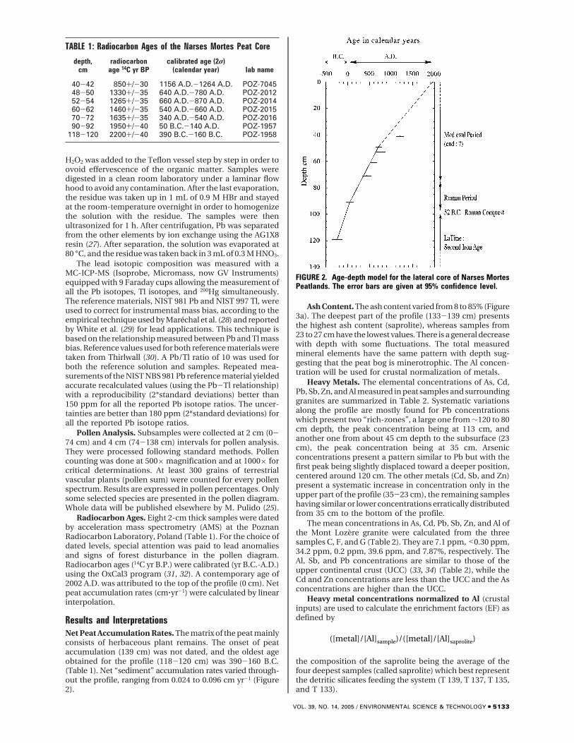
Radiocarbon Ages. Eight 2-cm thick samples were datedby acceleration mass spectrometry (AMS) at the PoznanRadiocarbon Laboratory, Poland (Table 1). For the choice ofdated levels, special attention was paid to lead anomaliesand signs of forest disturbance in the pollen diagram.Radiocarbon ages (14C yr B.P.) were calibrated (yr B.C.-A.D.)using the OxCal3 program (31, 32). A contemporary age of2002 A.D. was attributed to the top of the profile (0 cm). Netpeat accumulation rates (cm‚yr-1) were calculated by linearinterpolation.
Results and InterpretationsNet Peat Accumulation Rates. The matrix of the peat mainlyconsists of herbaceous plant remains. The onset of peataccumulation (139 cm) was not dated, and the oldest ageobtained for the profile (118-120 cm) was 390-160 B.C.(Table 1). Net “sediment” accumulation rates varied through-out the profile, ranging from 0.024 to 0.096 cm yr-1 (Figure2).
Ash Content. The ash content varied from 8 to 85% (Figure3a). The deepest part of the profile (133-139 cm) presentsthe highest ash content (saprolite), whereas samples from23 to 27 cm have the lowest values. There is a general decreasewith depth with some fluctuations. The total measuredmineral elements have the same pattern with depth sug-gesting that the peat bog is minerotrophic. The Al concen-tration will be used for crustal normalization of metals.
Heavy Metals. The elemental concentrations of As, Cd,Pb, Sb, Zn, and Al measured in peat samples and surroundinggranites are summarized in Table 2. Systematic variationsalong the profile are mostly found for Pb concentrationswhich present two “rich-zones”, a large one from ∼120 to 80cm depth, the peak concentration being at 113 cm, andanother one from about 45 cm depth to the subsurface (23cm), the peak concentration being at 35 cm. Arsenicconcentrations present a pattern similar to Pb but with thefirst peak being slightly displaced toward a deeper position,centered around 120 cm. The other metals (Cd, Sb, and Zn)present a systematic increase in concentration only in theupper part of the profile (35-23 cm), the remaining sampleshaving similar or lower concentrations erratically distributedfrom 35 cm to the bottom of the profile.
The mean concentrations in As, Cd, Pb, Sb, Zn, and Al ofthe Mont Lozere granite were calculated from the threesamples C, F, and G (Table 2). They are 7.1 ppm, <0.30 ppm,34.2 ppm, 0.2 ppm, 39.6 ppm, and 7.87%, respectively. TheAl, Sb, and Pb concentrations are similar to those of theupper continental crust (UCC) (33, 34) (Table 2), while theCd and Zn concentrations are less than the UCC and the Asconcentrations are higher than the UCC.
Heavy metal concentrations normalized to Al (crustalinputs) are used to calculate the enrichment factors (EF) asdefined by
the composition of the saprolite being the average of thefour deepest samples (called saprolite) which best representthe detritic silicates feeding the system (T 139, T 137, T 135,and T 133).
TABLE 1: Radiocarbon Ages of the Narses Mortes Peat Core
depth,cm
radiocarbonage 14C yr BP
calibrated age (2σ)(calendar year) lab name
40-42 850+/-30 1156 A.D.-1264 A.D. POZ-704548-50 1330+/-35 640 A.D.-780 A.D. POZ-201252-54 1265+/-35 660 A.D.-870 A.D. POZ-201460-62 1460+/-35 540 A.D.-660 A.D. POZ-201570-72 1635+/-35 340 A.D.-540 A.D. POZ-201690-92 1950+/-40 50 B.C.-140 A.D. POZ-1957
118-120 2200+/-40 390 B.C.-160 B.C. POZ-1958
FIGURE 2. Age-depth model for the lateral core of Narses MortesPeatlands. The error bars are given at 95% confidence level.
([metal]/[Al]sample)/([metal]/[Al]saprolite)
VOL. 39, NO. 14, 2005 / ENVIRONMENTAL SCIENCE & TECHNOLOGY 9 5133
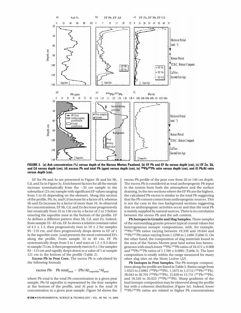
EF for Pb and As are presented in Figure 3b and for Sb,Cd, and Zn in Figure 3c. Enrichment factors for all the metalsincrease systematically from the ∼35 cm sample to thesubsurface (23 cm) sample with significant EF values rangingfrom 3 to 65 depending on the element. Along this sectionof the profile, Pb, As, and Cd increase by a factor of 4, whereasSb and Zn increase by a factor of more than 10. As observedfor concentrations, EF Sb, Cd, and Zn decrease progressivelybut erratically from 35 to 130 cm by a factor of 2 or 3 beforeentering the saprolite zone at the bottom of the profile. EFAs defines a different pattern than Sb, Cd, and Zn. Indeed,from sample 33-85 cm, EF As shows a relative constant valueof 4.5 ( 1.5, then progressively rises to 10 ( 2 for samples95-119 cm, and then progressively drops down to EF of 1in the saprolite zone. Lead presents the most contrasted EFsalong the profile. From sample 33 to 49 cm, EF Pbsystematically drops from 5 to 1 and stays at 1.5 ( 0.5 downto sample 75 cm. It then progressively rises to 9 ( 1 for samples93-113 cm and rapidly drops down to a value of 1 at sample121 cm to the bottom of the profile (Table 2).
Excess Pb in Peat Core. The excess Pb is calculated bythe following formula
where Pb total is the total Pb concentration in a given peatsample, Pb/Al saprolite is represented by the four samplesat the bottom of the profile, and Al peat is the total Alconcentration in a given peat sample. Figure 3d shows the
excess Pb profile of the peat core from 20 to 140 cm depth.The excess Pb is considered as total anthropogenic Pb inputin the system from both the atmosphere and the surfacedraining. In the two sections where the EF Pb are the highest,the calculated Pb excess is similar to the total Pb suggestingthat the Pb content comes from anthropogenic sources. Thisis not the case in the two background sections suggestingthat no anthropogenic activities occur and that the total Pbis mainly supplied by natural sources. There is no correlationbetween the excess Pb and the ash content.
Pb Isotopes in Granite and Slag Samples. Three samplesof the surrounding granite present typical crustal values butheterogeneous isotopic compositions, with, for example,206Pb/204Pb ratios varying between 19.339 and 19.644 and206Pb/207Pb ratios varying from 1.2298 to 1.2486 (Table 3). Onthe other hand, the composition of slag materials found inthe area of the Narses Mortes peat land seems less hetero-geneous with much lower 206Pb/204Pb ratios of 18.472 ( 0.008and 206Pb/207Pb ratios of 1.1789 ( 0.0001 (Table 3). The latercomposition is totally within the range measured for manyother slag sites on the Mont Lozere (22).
Pb Isotopes in Peat Samples. The Pb isotopic composi-tions along the profile are listed in Table 3. Ratios range from1.9325 to 2.0981 (208Pb/206Pb), 1.1675 to 1.2712 (206Pb/207Pb),38.043 to 38.701 (208Pb/204Pb), 15.630 to 15.751 (207Pb/204Pb),and 18.249 to 20.023 (206Pb/204Pb). Sharp gradients of thelead isotopic composition may be observed along the profilebut with a coherent distribution (Figure 3e). Indeed, lower206Pb/207Pb ratios are related to higher Pb concentrations
FIGURE 3. (a) Ash concentration (%) versus depth of the Narses Mortes Peatland, (b) EF Pb and EF As versus depth (cm), (c) EF Zn, Sb,and Cd versus depth (cm), (d) excess Pb and total Pb (ppm) versus depth (cm), (e) 206Pb/207Pb ratio versus depth (cm), and (f) Pb/Al ratioversus depth (cm).
excess Pb: Pb totalpeat - (Pb/Al)saprolite*Alpeat
5134 9 ENVIRONMENTAL SCIENCE & TECHNOLOGY / VOL. 39, NO. 14, 2005
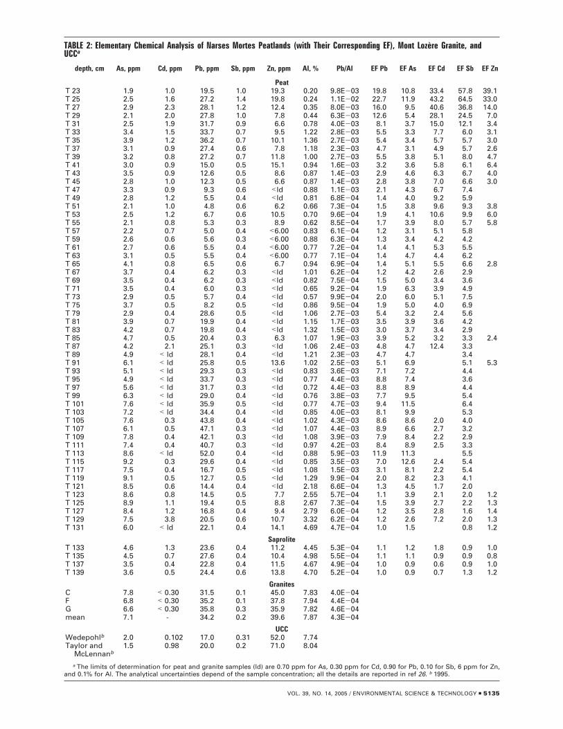
TABLE 2: Elementary Chemical Analysis of Narses Mortes Peatlands (with Their Corresponding EF), Mont Lozere Granite, andUCCa
depth, cm As, ppm Cd, ppm Pb, ppm Sb, ppm Zn, ppm Al, % Pb/Al EF Pb EF As EF Cd EF Sb EF Zn
PeatT 23 1.9 1.0 19.5 1.0 19.3 0.20 9.8E-03 19.8 10.8 33.4 57.8 39.1T 25 2.5 1.6 27.2 1.4 19.8 0.24 1.1E-02 22.7 11.9 43.2 64.5 33.0T 27 2.9 2.3 28.1 1.2 12.4 0.35 8.0E-03 16.0 9.5 40.6 36.8 14.0T 29 2.1 2.0 27.8 1.0 7.8 0.44 6.3E-03 12.6 5.4 28.1 24.5 7.0T 31 2.5 1.9 31.7 0.9 6.6 0.78 4.0E-03 8.1 3.7 15.0 12.1 3.4T 33 3.4 1.5 33.7 0.7 9.5 1.22 2.8E-03 5.5 3.3 7.7 6.0 3.1T 35 3.9 1.2 36.2 0.7 10.1 1.36 2.7E-03 5.4 3.4 5.7 5.7 3.0T 37 3.1 0.9 27.4 0.6 7.8 1.18 2.3E-03 4.7 3.1 4.9 5.7 2.6T 39 3.2 0.8 27.2 0.7 11.8 1.00 2.7E-03 5.5 3.8 5.1 8.0 4.7T 41 3.0 0.9 15.0 0.5 15.1 0.94 1.6E-03 3.2 3.6 5.8 6.1 6.4T 43 3.5 0.9 12.6 0.5 8.6 0.87 1.4E-03 2.9 4.6 6.3 6.7 4.0T 45 2.8 1.0 12.3 0.5 6.6 0.87 1.4E-03 2.8 3.8 7.0 6.6 3.0T 47 3.3 0.9 9.3 0.6 <ld 0.88 1.1E-03 2.1 4.3 6.7 7.4T 49 2.8 1.2 5.5 0.4 <ld 0.81 6.8E-04 1.4 4.0 9.2 5.9T 51 2.1 1.0 4.8 0.6 6.2 0.66 7.3E-04 1.5 3.8 9.6 9.3 3.8T 53 2.5 1.2 6.7 0.6 10.5 0.70 9.6E-04 1.9 4.1 10.6 9.9 6.0T 55 2.1 0.8 5.3 0.3 8.9 0.62 8.5E-04 1.7 3.9 8.0 5.7 5.8T 57 2.2 0.7 5.0 0.4 <6.00 0.83 6.1E-04 1.2 3.1 5.1 5.8T 59 2.6 0.6 5.6 0.3 <6.00 0.88 6.3E-04 1.3 3.4 4.2 4.2T 61 2.7 0.6 5.5 0.4 <6.00 0.77 7.2E-04 1.4 4.1 5.3 5.5T 63 3.1 0.5 5.5 0.4 <6.00 0.77 7.1E-04 1.4 4.7 4.4 6.2T 65 4.1 0.8 6.5 0.6 6.7 0.94 6.9E-04 1.4 5.1 5.5 6.6 2.8T 67 3.7 0.4 6.2 0.3 <ld 1.01 6.2E-04 1.2 4.2 2.6 2.9T 69 3.5 0.4 6.2 0.3 <ld 0.82 7.5E-04 1.5 5.0 3.4 3.6T 71 3.5 0.4 6.0 0.3 <ld 0.65 9.2E-04 1.9 6.3 3.9 4.9T 73 2.9 0.5 5.7 0.4 <ld 0.57 9.9E-04 2.0 6.0 5.1 7.5T 75 3.7 0.5 8.2 0.5 <ld 0.86 9.5E-04 1.9 5.0 4.0 6.9T 79 2.9 0.4 28.6 0.5 <ld 1.06 2.7E-03 5.4 3.2 2.4 5.6T 81 3.9 0.7 19.9 0.4 <ld 1.15 1.7E-03 3.5 3.9 3.6 4.2T 83 4.2 0.7 19.8 0.4 <ld 1.32 1.5E-03 3.0 3.7 3.4 2.9T 85 4.7 0.5 20.4 0.3 6.3 1.07 1.9E-03 3.9 5.2 3.2 3.3 2.4T 87 4.2 2.1 25.1 0.3 <ld 1.06 2.4E-03 4.8 4.7 12.4 3.3T 89 4.9 < ld 28.1 0.4 <ld 1.21 2.3E-03 4.7 4.7 3.4T 91 6.1 < ld 25.8 0.5 13.6 1.02 2.5E-03 5.1 6.9 5.1 5.3T 93 5.1 < ld 29.3 0.3 <ld 0.83 3.6E-03 7.1 7.2 4.4T 95 4.9 < ld 33.7 0.3 <ld 0.77 4.4E-03 8.8 7.4 3.6T 97 5.6 < ld 31.7 0.3 <ld 0.72 4.4E-03 8.8 8.9 4.4T 99 6.3 < ld 29.0 0.4 <ld 0.76 3.8E-03 7.7 9.5 5.4T 101 7.6 < ld 35.9 0.5 <ld 0.77 4.7E-03 9.4 11.5 6.4T 103 7.2 < ld 34.4 0.4 <ld 0.85 4.0E-03 8.1 9.9 5.3T 105 7.6 0.3 43.8 0.4 <ld 1.02 4.3E-03 8.6 8.6 2.0 4.0T 107 6.1 0.5 47.1 0.3 <ld 1.07 4.4E-03 8.9 6.6 2.7 3.2T 109 7.8 0.4 42.1 0.3 <ld 1.08 3.9E-03 7.9 8.4 2.2 2.9T 111 7.4 0.4 40.7 0.3 <ld 0.97 4.2E-03 8.4 8.9 2.5 3.3T 113 8.6 < ld 52.0 0.4 <ld 0.88 5.9E-03 11.9 11.3 5.5T 115 9.2 0.3 29.6 0.4 <ld 0.85 3.5E-03 7.0 12.6 2.4 5.4T 117 7.5 0.4 16.7 0.5 <ld 1.08 1.5E-03 3.1 8.1 2.2 5.4T 119 9.1 0.5 12.7 0.5 <ld 1.29 9.9E-04 2.0 8.2 2.3 4.1T 121 8.5 0.6 14.4 0.4 <ld 2.18 6.6E-04 1.3 4.5 1.7 2.0T 123 8.6 0.8 14.5 0.5 7.7 2.55 5.7E-04 1.1 3.9 2.1 2.0 1.2T 125 8.9 1.1 19.4 0.5 8.8 2.67 7.3E-04 1.5 3.9 2.7 2.2 1.3T 127 8.4 1.2 16.8 0.4 9.4 2.79 6.0E-04 1.2 3.5 2.8 1.6 1.4T 129 7.5 3.8 20.5 0.6 10.7 3.32 6.2E-04 1.2 2.6 7.2 2.0 1.3T 131 6.0 < ld 22.1 0.4 14.1 4.69 4.7E-04 1.0 1.5 0.8 1.2
SaproliteT 133 4.6 1.3 23.6 0.4 11.2 4.45 5.3E-04 1.1 1.2 1.8 0.9 1.0T 135 4.5 0.7 27.6 0.4 10.4 4.98 5.5E-04 1.1 1.1 0.9 0.9 0.8T 137 3.5 0.4 22.8 0.4 11.5 4.67 4.9E-04 1.0 0.9 0.6 0.9 1.0T 139 3.6 0.5 24.4 0.6 13.8 4.70 5.2E-04 1.0 0.9 0.7 1.3 1.2
GranitesC 7.8 < 0.30 31.5 0.1 45.0 7.83 4.0E-04F 6.8 < 0.30 35.2 0.1 37.8 7.94 4.4E-04G 6.6 < 0.30 35.8 0.3 35.9 7.82 4.6E-04mean 7.1 - 34.2 0.2 39.6 7.87 4.3E-04
UCCWedepohlb 2.0 0.102 17.0 0.31 52.0 7.74Taylor and
McLennanb1.5 0.98 20.0 0.2 71.0 8.04
a The limits of determination for peat and granite samples (ld) are 0.70 ppm for As, 0.30 ppm for Cd, 0.90 for Pb, 0.10 for Sb, 6 ppm for Zn,and 0.1% for Al. The analytical uncertainties depend of the sample concentration; all the details are reported in ref 26. b 1995.
VOL. 39, NO. 14, 2005 / ENVIRONMENTAL SCIENCE & TECHNOLOGY 9 5135
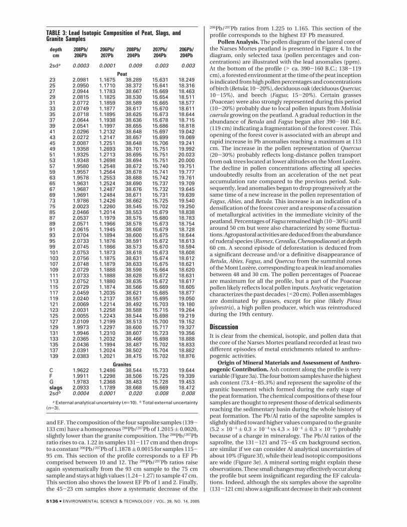
and EF. The composition of the four saprolite samples (139-133 cm) have a homogeneous 206Pb/207Pb of 1.2015 ( 0.0020,slightly lower than the granite composition. The 206Pb/207Pbratio rises to ca. 1.22 in samples 131-117 cm and then dropsto a constant 206Pb/207Pb of 1.1878 ( 0.0015 for samples 115-95 cm. This section of the profile corresponds to a EF Pbcomprised between 10 and 12. The 206Pb/207Pb ratios raiseagain systematically from the 93 cm sample to the 75 cmsample and stays at high values (1.24-1.27) to sample 47 cm.This section also shows the lowest EF Pb of 1 and 2. Finally,the 45-23 cm samples show a systematic decrease of the
206Pb/207Pb ratios from 1.225 to 1.165. This section of theprofile corresponds to the highest EF Pb measured.
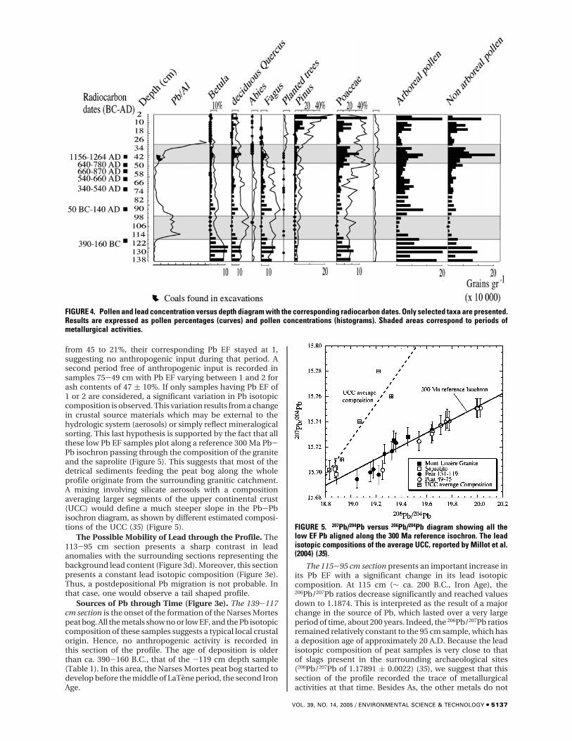
Pollen Analysis. The pollen diagram of the lateral core ofthe Narses Mortes peatland is presented in Figure 4. In thediagram, only selected taxa (pollen percentages and con-centrations) are illustrated with the lead anomalies (ppm).At the bottom of the profile (> ca. 390-160 B.C.; 138-119cm), a forested environment at the time of the peat inceptionis indicated from high pollen percentages and concentrationsof birch (Betula; 10-20%), deciduous oak (deciduous Quercus;10-15%), and beech (Fagus; 15-20%). Certain grasses(Poaceae) were also strongly represented during this period(10-20%) probably due to local pollen inputs from Moliniacaerula growing on the peatland. A gradual reduction in theabundance of Betula and Fagus began after 390-160 B.C.(119 cm) indicating a fragmentation of the forest cover. Thisopening of the forest cover is associated with an abrupt andrapid increase in Pb anomalies reaching a maximum at 113cm. The increase in the pollen representation of Quercus(20-30%) probably reflects long-distance pollen transportfrom oak trees located at lower altitudes on the Mont Lozere.The decline in pollen concentrations affecting all speciesundoubtedly results from an acceleration of the net peataccumulation rate compared to the previous period. Sub-sequently, lead anomalies began to drop progressively at thesame time of a new increase in the pollen representation ofFagus, Abies, and Betula. This increase is an indication of adensification of the forest cover and a response of a cessationof metallurgical activities in the immediate vicinity of thepeatland. Percentages of Fagus remained high (10-30%) untilaround 50 cm but were also characterized by some fluctua-tions. Agropastoral activities are deduced from the abundanceof ruderal species (Rumex, Cerealia, Chenopodiaceae) at depth60 cm. A second episode of deforestation is deduced froma significant decrease and/or a definitive disappearance ofBetula, Abies, Fagus, and Quercus from the summital zonesof the Mont Lozere, corresponding to a peak in lead anomaliesbetween 48 and 30 cm. The pollen percentages of Poaceaeare maximum for all the profile, but a part of the Poaceaepollen likely reflects local pollen inputs. Asylvatic vegetationcharacterizes the past decades (<20 cm). Pollen assemblagesare dominated by grasses, except for pine (likely Pinussylvestris), a high pollen producer, which was reintroducedduring the 19th century.
DiscussionIt is clear from the chemical, isotopic, and pollen data thatthe core of the Narses Mortes peatland recorded at least twodifferent episodes of metal enrichments related to anthro-pogenic activities.
Origin of Mineral Materials and Assessment of Anthro-pogenic Contribution. Ash content along the profile is veryvariable (Figure 3a). The four bottom samples have the highestash content (73.4-85.3%) and represent the saprolite of thegranitic basement which formed during the early stage ofthe peat formation. The chemical compositions of these foursamples are thought to represent those of detrical sedimentsreaching the sedimentary basin during the whole history ofpeat formation. The Pb/Al ratio of the saprolite samples isslightly shifted toward higher values compared to the granite(5.2 × 10⁻⁴ ( 0.3 × 10⁻⁴ vs 4.3 × 10⁻⁴ ( 0.3 × 10⁻⁴) probablybecause of a change in mineralogy. The Pb/Al ratios of thesaprolite, the 131-121 and 75-45 cm background section,are similar if we can consider Al analytical uncertainties ofabout 10% (Figure 3f), while their lead isotopic compositionsare wide (Figure 3e). A mineral sorting might explain theseobservations. These small changes may effectively occur alongthe profile but seem insignificant regarding the EF calcula-tions. Indeed, although the six samples above the saprolite(131-121 cm) show a significant decrease in their ash content
TABLE 3: Lead Isotopic Composition of Peat, Slags, andGranite Samples
depthcm
208Pb/206Pb
206Pb/207Pb
208Pb/204Pb
207Pb/204Pb
206Pb/204Pb
2sda 0.0003 0.0001 0.009 0.003 0.003
Peat23 2.0981 1.1675 38.289 15.631 18.24925 2.0950 1.1710 38.372 15.641 18.31627 2.0944 1.1783 38.667 15.669 18.46329 2.0815 1.1825 38.530 15.654 18.51131 2.0772 1.1859 38.589 15.665 18.57733 2.0749 1.1877 38.617 15.670 18.61135 2.0718 1.1895 38.625 15.673 18.64437 2.0644 1.1938 38.636 15.678 18.71539 2.0541 1.1997 38.655 15.686 18.81841 2.0296 1.2132 38.648 15.697 19.04243 2.0272 1.2147 38.657 15.699 19.06945 2.0087 1.2251 38.648 15.706 19.24149 1.9358 1.2693 38.701 15.751 19.99251 1.9325 1.2713 38.695 15.751 20.02353 1.9348 1.2698 38.694 15.751 20.00057 1.9580 1.2548 38.672 15.740 19.75159 1.9557 1.2564 38.678 15.741 19.77763 1.9578 1.2553 38.688 15.742 19.76165 1.9631 1.2524 38.690 15.737 19.70967 1.9687 1.2487 38.676 15.732 19.64569 1.9691 1.2484 38.671 15.731 19.63973 1.9786 1.2426 38.662 15.725 19.54075 2.0023 1.2260 38.545 15.702 19.25085 2.0466 1.2014 38.553 15.679 18.83887 2.0537 1.1979 38.575 15.680 18.78389 2.0571 1.1966 38.578 15.673 18.75491 2.0615 1.1945 38.608 15.679 18.72893 2.0704 1.1894 38.600 15.675 18.64495 2.0733 1.1876 38.591 15.672 18.61399 2.0745 1.1866 38.573 15.670 18.594101 2.0753 1.1873 38.618 15.673 18.608103 2.0756 1.1875 38.631 15.674 18.612107 2.0748 1.1879 38.633 15.675 18.621109 2.0729 1.1888 38.598 15.664 18.620111 2.0733 1.1888 38.628 15.672 18.631113 2.0752 1.1880 38.635 15.672 18.617115 2.0729 1.1874 38.566 15.669 18.605117 2.0459 1.2035 38.621 15.685 18.877119 2.0240 1.2137 38.557 15.695 19.050121 2.0069 1.2214 38.492 15.703 19.180123 2.0031 1.2258 38.588 15.715 19.264125 2.0055 1.2243 38.544 15.698 19.219127 2.0109 1.2199 38.513 15.700 19.152129 1.9973 1.2297 38.600 15.717 19.327131 1.9946 1.2310 38.607 15.723 19.356133 2.0365 1.2032 38.466 15.698 18.888135 2.0436 1.1994 38.487 15.702 18.833137 2.0391 1.2024 38.502 15.704 18.882139 2.0383 1.2021 38.475 15.702 18.876
GranitesC 1.9622 1.2486 38.544 15.733 19.644F 1.9911 1.2298 38.506 15.725 19.339G 1.9783 1.2368 38.483 15.728 19.453slags 2.0933 1.1789 38.668 15.669 18.4722sdb 0.0004 0.0001 0.020 0.008 0.008
a External analytical uncertainty (n)10). b Total external uncertainty(n)3).
5136 9 ENVIRONMENTAL SCIENCE & TECHNOLOGY / VOL. 39, NO. 14, 2005
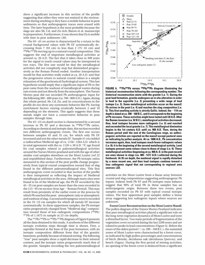
from 45 to 21%, their corresponding Pb EF stayed at 1,suggesting no anthropogenic input during that period. Asecond period free of anthropogenic input is recorded insamples 75-49 cm with Pb EF varying between 1 and 2 forash contents of 47 ( 10%. If only samples having Pb EF of1 or 2 are considered, a significant variation in Pb isotopiccomposition is observed. This variation results from a changein crustal source materials which may be external to thehydrologic system (aerosols) or simply reflect mineralogicalsorting. This last hypothesis is supported by the fact that allthese low Pb EF samples plot along a reference 300 Ma Pb-Pb isochron passing through the composition of the graniteand the saprolite (Figure 5). This suggests that most of thedetrical sediments feeding the peat bog along the wholeprofile originate from the surrounding granitic catchment.A mixing involving silicate aerosols with a compositionaveraging larger segments of the upper continental crust(UCC) would define a much steeper slope in the Pb-Pbisochron diagram, as shown by different estimated composi-tions of the UCC (35) (Figure 5).
The Possible Mobility of Lead through the Profile. The113-95 cm section presents a sharp contrast in leadanomalies with the surrounding sections representing thebackground lead content (Figure 3d). Moreover, this sectionpresents a constant lead isotopic composition (Figure 3e).Thus, a postdepositional Pb migration is not probable. Inthat case, one would observe a tail shaped profile.
Sources of Pb through Time (Figure 3e). The 139-117cm section is the onset of the formation of the Narses Mortespeat bog. All the metals show no or low EF, and the Pb isotopiccomposition of these samples suggests a typical local crustalorigin. Hence, no anthropogenic activity is recorded inthis section of the profile. The age of deposition is olderthan ca. 390-160 B.C., that of the -119 cm depth sample(Table 1). In this area, the Narses Mortes peat bog started todevelop before the middle of LaTene period, the second IronAge.
The 115-95 cm section presents an important increase inits Pb EF with a significant change in its lead isotopiccomposition. At 115 cm (∼ ca. 200 B.C., Iron Age), the206Pb/207Pb ratios decrease significantly and reached valuesdown to 1.1874. This is interpreted as the result of a majorchange in the source of Pb, which lasted over a very largeperiod of time, about 200 years. Indeed, the 206Pb/207Pb ratiosremained relatively constant to the 95 cm sample, which hasa deposition age of approximately 20 A.D. Because the leadisotopic composition of peat samples is very close to thatof slags present in the surrounding archaeological sites(206Pb/207Pb of 1.17891 ( 0.0022) (35), we suggest that thissection of the profile recorded the trace of metallurgicalactivities at that time. Besides As, the other metals do not
FIGURE 4. Pollen and lead concentration versus depth diagram with the corresponding radiocarbon dates. Only selected taxa are presented.Results are expressed as pollen percentages (curves) and pollen concentrations (histograms). Shaded areas correspond to periods ofmetallurgical activities.
FIGURE 5. 207Pb/204Pb versus 206Pb/204Pb diagram showing all thelow EF Pb aligned along the 300 Ma reference isochron. The leadisotopic compositions of the average UCC, reported by Millot et al.(2004) (35).
VOL. 39, NO. 14, 2005 / ENVIRONMENTAL SCIENCE & TECHNOLOGY 9 5137
show a significant increase in this section of the profilesuggesting that either they were not emitted in the environ-ment during smelting or they have a mobile behavior in peatsediments so that anthropogenic traces were erased withtime. The later hypothesis is the most probable because theslags are also Sb, Cd, and Zn-rich (Baron et al. manuscriptin preparation). Furthermore, it was shown that Zn is mobilewith time in peat sediments (36).
The 93-45 cm section is characterized by a return to thecrustal background values with Pb EF systematically de-creasing from 7 (93 cm) to less than 2 (75-45 cm) and206Pb/207Pb moving up to a natural crustal composition. Thissuggests the end of important metallurgical activities ataround ca. 20 A.D. The fact that it takes close to 300 yearsfor the signal to reach crustal values may be interpreted intwo ways. The first one would be that the metallurgicalactivities did not completely stop but diminished progres-sively as the Roman Period ended. Another interpretationwould be that activities really ended at ca. 20 A.D. and thatthe progressive return to natural crustal values is a simplerelaxation of the geochemical/hydrological system. This lasthypothesis would imply that a significant input of Pb to thepeat came from the washout of metallurgical wastes duringrain events and not directly from the atmosphere. The NarsesMortes peat did not recorded Pb anthropogenic input forthe following 300-400 years (ca. 700-800 A.D.). Again, duringthis whole period, Sb, Cd, Zn, and As concentrations in theprofile do not show any systematic behavior like Pb, havingenrichment factors varying erratically between 3 and 10depending on the element. This again suggests that thesemetals might not have a conservative behavior in peatsamples through time.
The 45-23 cm depth section is characterized by a secondincrease in Pb EF and a decrease in 206Pb/207Pb ratios.According to chemical and isotopic data, this section recordedtwo different anthropogenic events. The first one occursbetween samples 45 and 35 cm, for which only Pb EFincreased and not the other metals EF. Sample 41 cm yieldeda radiocarbon Medieval age of ca. 1156-1264 A.D. which isin total agreement with the ca. 1120 ( 30 A.D. 14C age foundfor coal samples related to paleometallurgical activitiesaround the Narses Mortes peatland and with the age of othersimilar coal samples elsewhere on the Mont Lozere (ref 22and unpublished data). Furthermore, the Pb isotopic ratiosmeasured in this section of the peat profile change progres-sively from typical crustal composition toward that of slagfound in the different paleometallurgical sites. This firstanthropogenic event recorded in that section of the profileis then interpreted as reflecting the impact of Medievalmetallurgical activities in the area. Although many sites werefound to be of the Medieval age, the Pb EF recorded by the45-35 cm peat samples are lesser than the ones recorded inthe 115-95 cm section (Iron Age - Roman Period). This mayresult from proximity of the earlier event or the process bywhich Pb reached the peat: atmospheric only or atmosphericand washout of slag. A second anthropogenic event is recordedin the 35-23 cm samples for which all metals EF increasesystematically. In these uppermost samples, the Pb isotoperatios progressively changed from “Medieval slag” composi-tion toward those of less radiogenic compositions (206Pb/207Pb of 1.1675 in sample at 23 cm depth).
The 207Pb/204Pb vs 206Pb/204Pb diagram of Figure 6 presentsall the data obtained in this study. A synthesis of the differentisotopic evolution steps through time is shown. First, asaprolite formed at the base of the peat formation, with anisotopic composition different from that of the graniticbasement, probably because of mineral sorting. The following“true” peat samples show a rapid decrease in their mineralcontent, and the isotopic ratios progressively reach that ofthe granite. Samples recording the two paleometallurgical
activities on the Mont Lozere form a linear array betweencrustal and slag compositions suggesting anthropogenic Pbinputs. Indeed, both Pb EF and Pb isotopes mass balancesuggest that 90% of total Pb in these samples has ananthropogenic origin. Between these two events, peatsamples recorded no Pb EF with typical crustal isotopicvalues. The four uppermost peat samples define a lineararray suggesting less radiogenic inputs where sources areunknown.
Forest Cover Reconstruction on the Mont Lozere Massif.The pollen diagram of the Narses Mortes Peatland indicatesthat past metallurgical activities played a significant role onthe long-term vegetation dynamics of Mont Lozere and werea disturbed factor. Two main periods of fragmentation of thevegetation cover occurred during the last 2200 years and arerelated to peaks in lead concentrations (Figure 4). Before theonset of the oldest period (> ca. 390-160 B.C.), the summitalzones of Mont Lozere were characterized by a forest cover,as indicated by high pollen percentages and concentrationsof birch (Betula), deciduous oak (deciduous Quercus), andbeech (Fagus). During the first period of mining activities,an opening of the forest cover is deduced from a significant
FIGURE 6. 207Pb/204Pb versus 206Pb/204Pb diagram illustrating thehistorical reconstruction following the corresponding number. Thehistorical reconstruction starts with the granite (i.e. 1). During thepeat land formation, granite undergoes an in situ alteration in orderto lead to the saprolite (i.e. 2) presenting a wide range of leadisotope (i.e. 3). Some metallurgical activities occur on the massif;Pb arrives in the peat (i.e. 4) and reaches the slag composition (i.e.5). This first smelting activity is strictly Gallic. Indeed, the -119 cmdepth is dated at ca. 390-160 B.C., and it corresponds to the beginningof Pb increase. These activities might have lasted until 20 A.D. Afterthe Roman invasion (ca. 52 B.C.), metallurgical activities decreased,thus, lead isotopes became more radiogenic (i.e. 6) and reachedand exceeded the local granite (i.e. 7). This metallurgical diminutionbegins in the 1st century A.D. until ca. 900 A.D. Then, during theRoman period until the end of the Carolingians reign, no anthro-pogenic activities are reported on the massif except pastoral onesas indicating by pollen analysis. At ca. 1000 A.D., Pb concentrationincreases again, thus, lead isotopes reach fewer radiogenic values(i.e. 8); it is the beginning of the second metallurgical activity. Leadisotopes present some values close to those of slags (i.e. 9). Thesemetallurgical activities (beginning at ca. 900 A. D. in the peat record)are ones shown in slags (ca. 985-1277 A.D.) collected during thefieldwork. At 35 cm depth, the medieval signal is rapidly disturbedby a more recent one, and then lead isotopes continue toward aless radiogenic signal that not corresponding to regional oressources (22).
5138 9 ENVIRONMENTAL SCIENCE & TECHNOLOGY / VOL. 39, NO. 14, 2005
decrease in the abundance of Fagus and Betula. Despite asynchronous increase in pollen percentages of deciduousQuercus at the same time, this species was probably alsoaffected by metallurgical activities. This increase in pollenpercentages likely reflects long-distance pollen transport fromoaks located at lower altitudes, in the Tarn valley. Theradiocarbon date obtained at depth 119 cm (ca. 390-160B.C.) indicating an Antique age for these first activities issupported by the presence of pollen of planted tree speciessuch as chestnut (Castanea) and walnut (Juglans).
A subsequent increase in the abundance of the above-mentioned arborescent species, especially Fagus, occurredat the same time of a gradual decrease in lead concentrations(Figure 4). These are an indication of a lower pressure ofmining activities on the vegetation cover and/or a cessationof mining activities in the vicinity of the peatland. Adensification of the forest cover is indicated by higher pollenpercentages and/or concentrations of Fagus, Betula, decidu-ous Quercus, and Abies.
The second episode of forest clearance, also associatedwith a peak in lead concentrations, happened more recentlyduring Medieval times. The representation of all tree speciesdeclined abruptly leading to the disappearance, amongothers, of beech and oak in the area where smelting slag sitesare located. The current asylvatic character of the summitalzones of the Mont Lozere is a response of human activitiesduring this period. If metallurgical activities exercised strongpressure on the forest cover during the Medieval period, thedeforestation is also likely the result of agropastoral activities.An abrupt increase in the representation of ruderal species(Chenopodiaceae, Rumex, Cerealia) occurred at 60 cm depth(ca. 540-660 A.D.) indicating an intensification of agropas-toral activities. For the moment, it is not possible to indicatewhat was the exact contribution of mining versus agropastoralactivities on the fragmentation of the forest cover. However,the high pollen representation of ruderal species until thetop of the record indicates that agriculture and pastoralisminhibited the reforestation of Mont Lozere after the cessationof medieval metallurgical activities, with the exception ofScots pine (Pinus sylvestris) planted during the second halfof the XIX century.
The Silver of the Gabales Tribe. The Gallic metallurgicalactivity occurring at 390-160 B.C. corresponds to the periodwhere the Lozere “departement” was the territory of theGabales tribe (Gaballum). Caesar (100-44 B.C.) in his book“De Bello Gallico” (58 B.C.) mentions that the Gabales tribe(37) lived in the present-day Lozere department. Furthermore,Strabon (58 B.C.-25 A.D.), in his book IV, 2.2, talked about“Gabales Silver” and Gallic metallurgy (38) in the same region.Actually, the settlement of “Javols” corresponds to the ancientcity of the Gabales tribe (Anderitum during the Roman period)as reported by the numerous excavations of the Gallo-Romancity. However, actually, there are no archaeological proofsabout metallurgical activities in this region This geochemicalrecord represents the first signs of local metallurgy for thisperiod. Furthermore, the pollen analyses complete andsupport the record. The geochemical and paleobotanical datacombined with the archaeological knowledge of the areaallowed a comprehensive interpretation and a better un-derstanding of ancestral activities. Then, mining heritageshould be taken account in order to not overestimate theimpact of modern pollutions (39) and to better understandthe origin of the old sources (40). The study of interactionsbetween early societies and their environment is essential inorder to better manage our present-day environment.
AcknowledgmentsThe grant was founded by ADEME (the French EnvironmentalAgency) and by Languedoc-Roussillon Region. All theanalyses have been supported by CRPG and SARM (CNRS),
in Nancy. We thank the CERL of Mende and the NationalPark of Cevennes for their assistance. Thanks to the “Saint-Etienne du Valdonnez” commune and its mayor, ClaudeFeybesse, for his technical support during fieldwork and hisgood reception. Special thanks to Jean Peytavin. We alsothank the SRA for supporting the “Programme Collectif deRecherche” entitled “Plomb ancien du Mont Lozere”. Thiswork is included in this P.C.R., all of the members contributingto a multidisciplinary approach. Thanks to Larry and Lauriefor English corrections.
Literature Cited(1) Hong, S.; Candelone, J. P.; Pattterson, C. C.; Boutron, C. F. History
of Ancient Copper Smelting Pollution During Roman andMedieval Times Recorded in Greenland Ice. Science 1996, 272,246-249.
(2) Rosman, K. J. R.; Chisoholm, W.; Hong, S; Candelone, J.-P.;Boutron, C. F. Lead from Carthaginian and Roman Spanishmines isotopically identified in Greenland ice dated from 600BC to 300 AD. Environ. Sci. Technol. 1997, 31, 3413-3416.
(3) Weiss, D.; Shotyk, W.; Boyle, E. A.; Kramers, J. D.; Appleby, P.G. ; Cherburkin, A. K. Comparative study of the temporalevolution of atmospheric lead deposition in Scotland and easternCanada using blanket peat bogs. Sci. Tot. Environ. 2002, 292,7-18.
(4) Shotyk, W.; Goodsite, M. E.; Roos-Barraclough, F.; Frei, R.;Heinemeier, J.; Asmund, G.; Lohse, C.; Hansen, T. S. Anthro-pogenic contributions to atmospheric Hg, Pb and As ac-cumulation recorded by peat cores from southern Greenlandand Danemark dated using the 14C “bomb pulse curve”.Geochim. Cosmochim. Acta 2003, 67, 3991-4011.
(5) Brannvall, M. L.; Bindler, R.; Rendberg, I.; Emteryd, O.; Bartnicki,J.; Billsrtom, K. The Medieval Metal Industry Was the Craddleof Modern Large-Scale Atmospheric Lead Pollution in NorthernEurope. Environ. Sci. Technol. 1999, 33, 4391-4395.
(6) Veron, A.; Lambert, C. E.; Isley, A.; Linet, P.; Grousset, F. Evidenceof recent lead pollution in deep north-east Atlantic sediments.Nature 1987, 326, 278-281.
(7) Eades, J. L.; Farmer, J. G.; MacKenzie, A. B.; Kirika, A.; Bailey-Watts, A. E. Stable lead isotopic characterisation of the historicalrecord of environmental lead contamination in dated freshwaterlake sediment cores from northern and central Scotland. Sci.Tot. Environ. 2002, 292, 55-67.
(8) Flegal, A. R.; Nriagu, J. O.; Niemeyer, S.; Coalf, K. H. IsotopicTracer of Lead Contamination in The Great Lakes. Nature 1989,339, 898-991.
(9) Carignan, J.; Simonetti, A.; Gariepy, C. Dispersal of atmosphericlead in northeastern North America as recorded by epiphyticlichens. Atmos. Environ. 2002, 36, 3759-3766.
(10) Doucet, C.; Carignan, J. Atmospheric Pb isotopic compositionand trace meatl concentration as revealed by epiphytic lichens:an investigation related to two altitudinal sections in EasternFrance. Atmos. Environ. 2001, 35, 3681-3690.
(11) Monna, F.; Aiuppa, A.; Varrica. D.; Dongarra, G. Pb isotopecomposition in lichens and aerosols from Eastern Sicily: insightsinto regional impact of volcanoes on the environment. Environ.Sci. Technol. 1999, 33, 2517-2523.
(12) Weiss, D.; Shotyk, W.; Rieley, J.; Page, S.; Gloor, M.; Reese, S.;Martinez-Cortizas, A. The geochemistry of major and selectedtrace elements in a forested peat bog, Kalimantan, SE Asia, andits implications for past atmospheric dust deposition. Geochim.Cosmochim. Acta 2002, 66, 2307-2323.
(13) Shotyk, W.; Weiss, D.; Appleby, P. G.; Cheburkin, A. K.; Frei, R.;Gloor, M.; Kramers, J. D.; Reese, S.; Van Der Knaap, W. O. Historyof atmospheric lead deposition since 12,370 14C yr BP from apeat bog, Jura Moutains, Switzerland. Science 1998, 281, 1635-1640.
(14) Monna, F.; Petit, C.; Guillaumet, J. P.; Jouffroy-Bapicot, I.;Blanchot, C.; Losno, R.; Richard, H.; Leveque, J.; Chateau, C.History and environmental impact of mining activity in CelticAeduan territory recorded in a Peat bog (Morvan, France).Environ. Sci. Technol. 2004, 38, 665-672.
(15) Nieminem, T. M.; Ukonmaanaho, L.; Shotyk, W. Enrichment ofCu, Ni, Zn, Pb and As in an ombrotrophic peat bog near a Cu-Ni smelter in Southwest Finland. Sci. Tot. Environ. 2002, 292,81-89.
(16) Allee, Ph. Habilitation a diriger des Recherches, University ofLimoges, 2003; p 451.
(17) Ploquin, A.; Allee, Ph.; Bailly-Maıtre, M. C.; Baron, S.; De Beaulieu,J. L.; Carignan, J.; Laurent, S.; Lavoie, M.; Mahe-Le Carlier, C.;
VOL. 39, NO. 14, 2005 / ENVIRONMENTAL SCIENCE & TECHNOLOGY 9 5139
Peytavin, J.; Pulido, M. In Medieval Lead Smelting on the Mont-Lozere, Southern France; International Conference of Archaeo-metallurgy in Europe; Actes du Colloque, Milan, 2003.
(18) Shotyk, W. Peat bog archives of atmospheric metal deposition:geochemical evaluation of peat profiles, natural variations inmetal concentrations, and metal enrichment factors. Environ.Rev. 1996, 4, 149-183.
(19) Shotyk, W.; Weiss, D.; Kramers, J. D.; Frei, R.; Cheburkin, A. K.;Gloor, M.; Reese, S. Geochemistry of the peat bog at Etang dela Gruere, Jura Mountains, Switzerland, and its record ofatmospheric Pb and lithogenic trace metals (Sc, Ti, Y, Zr, andREE) since 12,370 14C yr BP. Geochim. Cosmochim. Acta 2001,65, 2337-2360.
(20) West, S.; Charman, D. J.; Grattan, J. P.; Cheburkin, A. K. Heavymetals in Holocene peats from South West England: detectingmining impacts and atmospheric pollution. Water, Air, SoilsPollut. 1997, 100, 343-353.
(21) Shotyk, W. The chronology of anthropogenic, atmospheric Pbdeposition recorded by peat cores in the three minerogenicpeat deposits from Switzerland. Sci. Tot. Environ. 2002, 292,19-31.
(22) Baron, S.; Carignan, J.; Ploquin, A. Medieval lead making on theMont-Lozere Massif (Cevennes-France): ores tracing sourcesby using Pb isotopes. Appl. Geochem. Accepted with minorcorrections.
(23) Lavoie, M.; Pulido, M.; Baron, S.; Ploquin, A.; de Beaulieu, J.-L.;Bailly-Maitre, M.-C.; Carignan, J.; Allee, P.; Laurent, S.; Mahe LeCarlier, C.; Peytavin, J. Actes du Seminaire de Pierrefort.Submitted in November 2003.
(24) Beaulieu, J.-L. de. Plant cover evolution on the CevenoleMountain Border in the post-glacial period by using pollensanalysis. Bull. Soc. Languedoc. Geogr. 1974, 8, 247-258.
(25) Pulido, M. Ph.D. Thesis. In preparation, Universite d’Aix-Marseille III.
(26) Carignan, J.; Hild, P.; Mevelle, G.; Morel, J.; Yeghicheyan, D.Routine Analysis of Trace Elements in Geological Samples usingFlow Injection and Low-Pressure On-Line Liquid Chromatog-raphy Coupled to ICP-MS: A Study of Geochemical ReferenceMaterials BR, DR-N, UB-N, AN-G and GH. Geostand. Newsl.2001, 25, 187-198.
(27) Strelow, F. W. E. Quantitative separation of bismuth from lead,cadmium, and other elements by anion exchange chromatog-raphy with hydrobromic acid-nitric acid elution. Anal. Chem.1981, 53 (11), 1637-1640.
(28) Marechal, C.; Telouk, P.; Albarede, F. Precise analysis of copperand zinc isotopic compositions by plasma-source mass spec-trometry. Chem. Geol. 1999, 156, 251-273.
(29) White, W. M.; Albarede, F.; Telouk, P. High-precision analysisof Pb isotope ratios by multi-collector ICP-MS. Chem. Geol.2000, 167, 257-270.
(30) Thirlwall, M. F. Multicollector ICP-MS analysis of Pb isotopesusing a 207Pb-204Pb double spike demonstrates up to 400 ppm/amu systematic errors in Tl-normalisation. Chem. Geol. 2002,184, 255-279.
(31) Ramsey, C. B. Radiocarbon Calibration and Analysis of Stratig-raphy: The OxCal Program Radiocarbon. Radiocarbon 1995,37(2), 425-430.
(32) Ramsey, C. Oxcal 3b2 program, 1998, www.rlaha.ax.co.uk.(33) Wedepohl, K. H. The composition of the crust. Geochim.
Cosmochim. Acta 1995, 59(7), 1217-1232.(34) Taylor, S. R.; McLennan, S. M. The geochemical evolution of
the continental crust. Rev. Geophysics 1995, 33, 241-265.(35) Millot, R.; Allegre, C. J.; Gaillardet, J.; Roy, S. Lead isotopic
systematics of major river sediments: a new estimate of the Pbisotopic composition of the Upper Continental Crust. Chem.Geol. 2004, 203, 75-90.
(36) Kempter, H.; Frenzel, B. The impact of early mining and smeltingon the local tropospheric aerosols detected in ombrotrophicpeat bogs in the Harz, Germany. Water, Air, Soil Pollut. 2000,121, 93-108.
(37) Julius Cesare, in De Bello gallico, 52 B.C.(38) Strabon, in Etudes Geographiques 64 B.C.-23 A.D. Book, IV, 2.2.(39) Semlali, R. M.; Dessogne, J. B.; Monna, F.; Bolte, J.; Azimi, S.;
Navarro, N.; Denaix, L.; Loubet, M.; Chateau, C.; Van Oort, F.Modeling Lead Input and Output in Soils Using Lead IsotopicGeochemistry. Environ. Sci. Technol. 2004, 38, 1513-1521.
(40) Pyatt, F. B.; Gilmore, G.; Grattan, J. P.; Hunt, C. O.; McLaren,S. An Imperial Legacy? An Exploration of the EnvironmentalImpact of Ancient Metal Mining and Smelting in SouthernJordan. J. Archaeol. Sci. 2000, 27, 771-778.
Received for review November 22, 2004. Revised manuscriptreceived April 15, 2005. Accepted May 4, 2005.
ES048165L
5140 9 ENVIRONMENTAL SCIENCE & TECHNOLOGY / VOL. 39, NO. 14, 2005


![2015 Brief - FR [Angkor Photo Festival & Workshops]](https://img.pdfslide.fr/doc/110x75/5790535f1a28ab900c8c139b/2015-brief-fr-angkor-photo-festival-workshops.jpg)